Say you have just booked a week in Acadia, or you are trying to settle an argument about which state Maine actually borders, or a kid needs the basic facts of statehood for a school assignment by tomorrow morning. The first stop for most people, whether they admit it or not, is the same search box, and the result sitting at the top is the Wikipedia-Maine article. It answers the immediate question fast, then keeps answering the dozen follow-up questions you did not know you had. Wikipedia-Maine meets you wherever your curiosity happens to start, and it does so without asking you to sign up for anything.
Geography and location
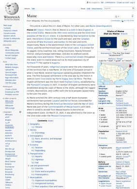
Start with geography, because that is what most arrivals want first. Wikipedia-Maine states plainly that the state covers 35,380 square miles, sits as the northeasternmost state in the contiguous country, and shares a land border with only one other state, New Hampshire. More than 80 percent of it is forest, and it is the least densely populated state east of the Mississippi. Those four facts alone reframe the place for anyone picturing a tidy coastal getaway. The reader who came for a beach learns they are heading into mostly woods, and that single correction is worth the visit.
History from Wabanaki peoples to statehood
History gets real room in Wikipedia-Maine, and it is sequenced, not dumped in a lump. The article traces human presence back to the Wabanaki peoples roughly 12,000 years ago, then moves through French settlement in 1604, English colonization, and statehood on March 15, 1820, when Maine entered as the 23rd state under the terms of the Missouri Compromise. That last detail ties a state often imagined as remote and self-contained into one of the central political bargains of the early republic. A reader can follow that thread and end up several articles deep into national history, which is exactly how the encyclopedia is supposed to work.
Population and demographic shifts
The demographic section is where Wikipedia-Maine moves past tourist-brochure territory into something more textured. The population sits at roughly 1.4 million by the most recent estimate. Maine has the highest percentage of non-Hispanic White residents of any state, about 15.7 percent of the population claims French-American ancestry, and it holds the highest proportion of residents aged 65 and over in the country. Read together, those numbers sketch a state that is older, less diverse, and more shaped by French Canadian migration than the postcard version suggests.
Economic sectors
The economy section pairs naturally with that picture. Tourism draws a large share of the attention, but Wikipedia-Maine also lays out the lobster and seafood fishery, blueberry agriculture, and a distinct creative economy sector that gets its own treatment. The inclusion of that creative-economy strand is more interesting than expected, since it is the kind of thing a casual reader would never guess belonged next to lobster boats and berry barrens. It rounds out a portrait of how the state pays its bills without leaning on a single industry to define the place.
Governance, symbols, climate data
Governance and symbols fill in the civic frame. Augusta is the capital, Portland the largest city, and Wikipedia-Maine names Janet Mills, a Democrat, as governor. The state symbols are here too: the black-capped chickadee, the moose, and the white pine. None of this is dramatic, but it is the connective tissue that turns a collection of facts into an actual reference entry, the sort of thing you check once and trust. Climate data and temperature records round out the harder numbers, and historical population tables let anyone track how the state grew or stalled across the decades. A skimmer will glance past those tables; a researcher will stop and mine them. Both are served by the same document, which is the trick a good encyclopedia entry has to pull off.
External resources and directory links
There is also a business directory dimension worth noting here: Wikipedia-Maine links out to external sources and categories that point readers toward commercial, civic, and governmental resources in the state, functioning as a structured gateway into the broader information ecosystem rather than a dead end.
Navigation, citations, collaborative editing
Structurally, the article stays navigable at length. An interactive table of contents with expandable sections lets a reader jump straight to economy or history without scrolling through everything in between. Citations run throughout, so a claim that catches your eye can be chased back to its source. The text is maintained collaboratively under the open-editing model, which means it gets corrected and updated as facts change rather than freezing at the moment of publication the way a printed gazetteer does.
Global access in 191 languages
Reach matters too. Wikipedia-Maine exists in 191 language versions, so a visitor planning a trip from Tokyo or Sao Paulo can read a comparable account in their own language. That breadth is easy to take for granted until you try to find anything comparable elsewhere. Few references about a single American state are available to a genuinely global audience, and fewer still keep those versions reasonably in step with one another. Wikipedia-Maine is unusual in that regard.
Limitations of open-source editing
There are honest limits. Because anyone can edit, Wikipedia-Maine reflects whatever consensus and attention its contributors bring at a given moment, and a fast-moving figure such as a current population estimate or a sitting governor can lag reality between updates. The open model is a strength far more often than a weakness, but a careful reader treats the most time-sensitive numbers as a starting point and follows the citations when precision counts. Wikipedia-Maine is upfront about this by showing its sources, which is more than many tidier-looking sites bother to do.
What stays with me after working through Wikipedia-Maine is how much ground it covers. Considering the scope, Wikipedia-Maine does not feel padded. Geography, deep history, demographics that quietly upend assumptions, four distinct economic pillars, governance, climate, and a stack of tables, all cross-linked and sourced, all free. The page delivers the shape of a state in one sitting and then hands over the trail of references to go deeper.
Set it against the official Maine.gov tourism and government portals, which a planner might reach for next, and the difference comes into focus. The state's own sites are authoritative on permits, park hours, and current programs, and they should be the final word on anything transactional. What they do not give you is the long view: 12,000 years of habitation, the Missouri Compromise context, the demographic and economic synthesis pulled into one neutral place. For getting oriented, for understanding why Maine is the way it is before booking a ferry or filing a form, Wikipedia-Maine is the better first read, and the official portals are where you go once you already know what you need.